Advertisement
Advertisement
Asia travel
Get more with myNEWS
A personalised news feed of stories that matter to you
Learn more
Barbed wire and fences are common on the Pyeonghwa Nuri-gil bike path, in South Korea along the Demilitarised Zone, but the route also meanders through farmland, past rice paddies, rivers and wildlife. Photo: Matthew C. Crawford

Korean DMZ bike trail offers bucolic scenes of farmers, fishing and mountains – not what you might expect so close to a hostile frontier

  • South Korea’s Pyeonghwa Nuri-gil ‘peace country path’ is near Seoul, and leads cyclists through miles of countryside at the edge of the border with North Korea
  • The ride features rivers, rice paddies, cows and ducks, and, with the main danger probably heatstroke, those looking for a battlefield will be disappointed
Asia travel

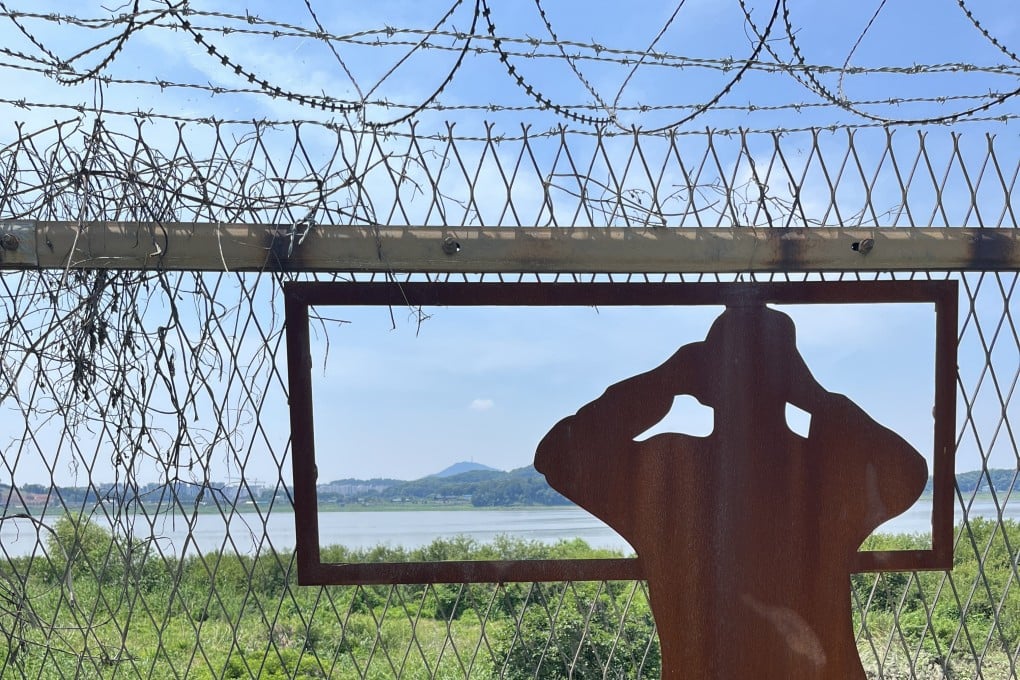
Living in Seoul, it’s easy to tune out thoughts of North Korea, a rogue state just 50km away yet completely sealed off from the outside world. However, a bike path that runs along a stretch of the demilitarised zone (DMZ) near the South Korean capital has piqued my curiosity.

The Pyeonghwa Nuri-gil (“peace country path”) was opened in 2010 and is currently split into seven sections, running east to the border of Gyeonggi and Gangwon provinces, close to Baekmagoji station, which is serviced by the infrequently running Peace Train. The trail is being extended, though, and will, when it’s complete, run all the way to the east coast of the Korean peninsula.

The DMZ is said to be the most militarised place on Earth and the North is suffering a dire food shortage. It’s not clear how the country is faring with Covid-19 and the hermit state has been making bold statements about its military missile capabilities. These are worrying issues, but the main risk of a cycling trip near North Korea at this time of year is probably heatstroke.

At 215km, the completed section of Pyeonghwa Nuri-gil is about as long as the lengthiest stage of the Tour de France. Top riders need five hours to cover that distance on good roads, so, anticipating less than perfect surfaces, I optimistically budget a full Sunday, being sure to catch the first subway train of the day. The Seoul Metro welcomes bicycles on weekends and holidays.

The first stretch of the Pyeonghwa Nuri-gil bike path, near the South Korean side of the DMZ. Photo: Matthew C. Crawford

After taking Line 7 then Incheon Line 2 to their terminuses, I emerge from the Geomdan Oryu station to the chirping of birds, the hissing of insects and rising humidity.

Riding through an industrial area of box-like factories, the scenery shifts to farmland. A whiff of manure lets me know the big city is already far behind.

A sign shows a map of part of the Pyeonghwa Nuri-gil bike path. Photo: Matthew C. Crawford

Cruising along the road to Daemyeong Port, a place of squawking seagulls and raw fish emporiums, I’m eager to start course one of seven. After an awkward dirt trail, I begin to see helpful trail infrastructure: aluminium route signs and a blue line to follow painted on the road.

Thus begins a hypnotic sequence of 90-degree turns and straightaways through paddies on narrow farmers’ roads. The emerald-green rice stalks sashay and whisper in the warm breeze; egrets’ heads poke up here and there like cheeky white periscopes.

It’s monsoon season, and recent torrents have littered the roads with stones and silt, making me regret my choice of a road bike, especially when I come upon a strip of soft, wet dirt, with an excavator roaring and scraping away at the far end.

The Pyeonghwa Nuri-gil bike path passes through verdant farmland along the DMZ. Photo: Matthew C. Crawford

Soon, though, I’m speeding north on asphalt next to a heavy-duty fence topped with razor wire, with ducks and cormorants camped out on the mud beyond and a muggy view of Ganghwa Island further off.

The entire Korean royal court fled to Ganghwa during the Mongol invasions (from 1231 to 1270), but it’s now more of a beach and camping destination.

As I close in on the northern part of the Gimpo Peninsula, just 2km from North Korea, a heavy fog descends. Out of white cloud appears a barrier gate manned by two young soldiers wearing automatic weapons and camouflage boonie hats. One steps forward apologetically to request an ID and passes over a clipboard with a form to fill out.

A pass is needed to ride a bike through the Civilian Control Zone. Photo: Matthew C. Crawford

“Is that North Korea?” I ask, gesturing at the whiteout conditions.

“Sure is,” he replies, handing me the pass I need to go any further (“Civilian Control Zone Entry/Period of Entry: 30 minutes before sunrise to 30 minutes after sunset/2nd Marine Divisional Commander,” it says) and saluting as I stand and pedal to get moving again.

On my left are the neutral waters between the two Koreas, an estuary that has been closed to shipping for about 70 years. Surprisingly, fields and paddies line the road here in the Civilian Control Zone, a reminder that many South Koreans couldn’t care less about the threat of the North.

South Korean fishermen relaxing close to the DMZ and a few kilometres away from North Korea. Photo: Matthew C. Crawford

A couple of kilometres after entering the control zone I leave again, handing back my pass at another checkpoint.

Noon is approaching when I reach the east side of the Gimpo Peninsula and the well-developed cycling infrastructure of the Han River.

There’s still plenty of Cold War scenery – barbed wire, camouflaged watchtowers, barricades – and the path is doubly fenced off from the river because there have been incursions by North Korean special forces. But I’m riding among other cyclists now, most shielded from the sun with elastic face masks and forearm protectors.

South Korean cyclists cross the Han River on the Pyeonghwa Nuri-gil bike path along the Demilitarised Zone. Photo: Matthew C. Crawford

Speeding along a berm, past shaded benches and a wetland park, I pass Sunday riders of every description, from dainty young ladies with front baskets to eccentrics with fat tyres and husbands and wives riding tandem in matching outfits.

Heading back towards the capital, the mountains of northern Seoul loom hazily on the horizon like an overexposed photo. No sooner do I enter the city limits than signs direct me across the Haengju Bridge and sharply northwards again, on course number three.

Riding past vinyl greenhouses along a highway that technically continues up to Pyongyang, I’m able to hold my bike’s drop bars at their lowest point and ride on autopilot for a while.

Hiking the DMZ: ‘peace trail’ offers soldier’s-eye view of Koreas

At the 100km mark, I’m tempted by a sign pointing to the Urban Grove coffee shop, where I find Giant and Cervélo bikes worth a small fortune parked out front. To counter the day’s heat, I order a coconut smoothie and wash it down with a Calamansi Slurpee before devouring some packed sweet potatoes.

My rattan chair is beginning to feel extremely comfortable, but then a lounge version of U2’s New Year’s Day begins oozing from the speakers, motivating me to return to the saddle.

With the glitzy cafes of Paju Book City, a publishing company cluster, and Heyri Art Valley behind me, I close in on the low residential blocks of Munsan, the closest town of any size to the DMZ.

The Imjin River, which flows from North Korea into South Korea along the Demilitarised Zone. Photo: Matthew C. Crawford

Few cyclists have made it up this far today, and the ones who pass going southwards look gassed. A middle-aged fellow rolls past biting his lip in concentration, gripping his straight handlebars like a tightrope walker might his balancing pole.

Reaching Bangu Pavilion, just upriver from where the snaking Imjin merges with the Han, I stop to ease a crick in my neck and take in the view. Chosen by the politician-scholar Hwang Hui (1363-1452) as a place to spend his retirement, the site’s original buildings were burned down during the Korean war (1950-1953) but faithfully replaced decades later.

I make my way up a set of bulbous stone steps towards the russet brown beams and sea-foam-green underside of the pavilion’s gently curving eaves. Sitting there on the wooden floor with legs outstretched is a bespectacled old lady with curly grey hair, totally absorbed in a smartphone game.

Bangu Pavilion is a historic site along the Pyeonghwa Nuri-gil bike path. Photo: Matthew C. Crawford

The journey continues with another intricate dance from one farmers’ road to another. Dramatic white clouds have formed near the horizon, tinged with a trace of pink, and nature seems to be overflowing from the hills.

For its abundance of wildlife, including leopard cats and golden eagles, the area hugging the DMZ is protected as a Unesco biosphere reserve, and it’s no surprise to see a road sign warning of wild boar.

As I ride deeper into the countryside and the sun begins to slant down, the rice stalks appear greener and the hills, plains and weeded ravines grow grander and more haunting. Often, the path is violated by creeping kudzu vines, which breathe out a spicy odour.

A pair of binoculars for viewing North Korea from the South. Photo: Matthew C. Crawford

I pass a boarded-up primary school and abandoned houses collapsing inward. Do I sense the ghosts of Korean, Chinese or United Nations forces who died here during the Korean war? Or do I just need another drink break?

Approaching Jangnam Bridge, a scaly mosaic of orange, green and black slithers into the tall weeds, possibly a venomous tiger keelback snake. Then, with the sun glowing like an ember on a mountain ridge, I turn a bend and grip the brakes, stopping short of a hulking black-and-white cow.

A sweaty farmer is standing nearby. Gritting his teeth, he yanks a frayed rope and growls, “Come on!”

A wandering cow adjoins the Pyeonghwa Nuri-gil bike path. Photo: Matthew C. Crawford

We’re both too tired for conversation, and the cow’s busy munching on fresh greens, but I can see from a glimmer in his eye that he’s found humour in the situation. The cow makes way, and I ride off sorely towards Soyosan station, the northern end of Seoul Metro’s Line 1.

If history had taken a different track, perhaps I’d have ridden the last 20km into the fading daylight, to reach the Pyeonghwa Nuri-gil’s current end point: a tunnel for a North Korea-bound train that stopped running in 1945.

Post