Millions of years ago the Yangtze River basin was a sea, study finds
- Research on ancient fish fossils provides new evidence for existence of the Yangtze Sea some 438 million years ago
- Fossils were preserved in sedimentary rock layers known as red beds that formed during the Silurian geological period
But some geologists believe the basin, which is home to about a third of China’s population, was a sea 438 million years ago – and a recent study on fish fossils provides new evidence for this.
“Called the Yangtze Sea, its [existence] has been confirmed by multiple pieces of scientific evidence,” Gai Zhikun, a professor at the Chinese Academy of Sciences’ Institute of Vertebrate Palaeontology and Palaeoanthropology, said on Wednesday.
His team classified and compared fish fossils collected from across China for the study. Their findings on the fossils from the Yangtze region were published in the peer-reviewed Journal of Stratigraphy in June.
The fossils were preserved in sedimentary rock layers known as red beds – coloured red by the mineral haematite – that formed in the Silurian, a geological period that lasted from about 443 to 419 million years ago.
The fossils were all of the same prehistoric species that emerged in the early Silurian period and rapidly evolved: the galeaspid, a jawless armoured fish.
“The galeaspid fish was a weak swimmer, and it lived in shallow seas,” Gai said.
Red beds were formed in shallow waters. As the sea level retreated, fine clasts containing haematite accumulated on the seabed and when rocks formed that haematite was preserved in the sediments.
The researchers concluded that the discovery of the fish fossils and the existence of red beds proved that the Yangtze region was a sea during the early Silurian period.
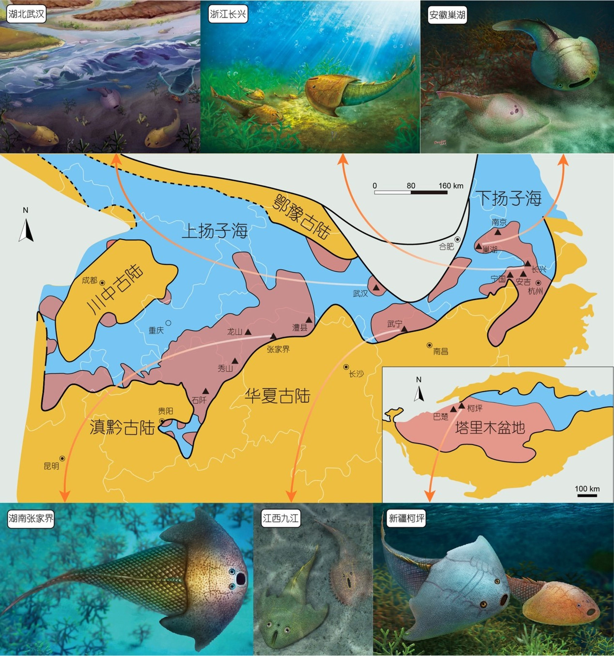
Other parts of China also looked different during this time, according to a geographic map of the China plate during the Silurian period – based on the distribution of red beds – drawn up by the team.

They found that the Yangtze Sea was surrounded by four ancient land plates. And the sea is believed to have disappeared as a result of the movement of those plates – moving more and moving closer to each other – in the following period.
The Yangtze region gradually rose and the sea drained away after the Silurian period.
Gai said the fish fossils were the key evidence for this continental drift hypothesis.
“The presence of [galeaspid] fish fossils in the Tarim Basin – the biggest basin in northwest China – is highly consistent with the presence of the fish fossils in south China in the same geographic layer,” he said.
“It indicates that the two land plates that are 4,000km [2,500 miles] apart today may have belonged to the same sea area at that time.”
Great flood may have helped ancient Chinese civilisation expand
The study found that the Tarim Block was once connected to the South China Block. “The Tarim Block drifted slowly from the south China region, and the South China Block moved eastward,” Gai said.
The palaeontologist said development in rural parts of China had helped the study as areas that had previously been covered by vegetation were cleared for construction.
He recalled how they had made an unexpected discovery after taking a detour from a highway in eastern Jiangxi province due to roadworks. The researchers ended up at a construction site where they stumbled across fish fossils, prompting detailed investigation around the site and leading them to correct a conclusion in their paper.

