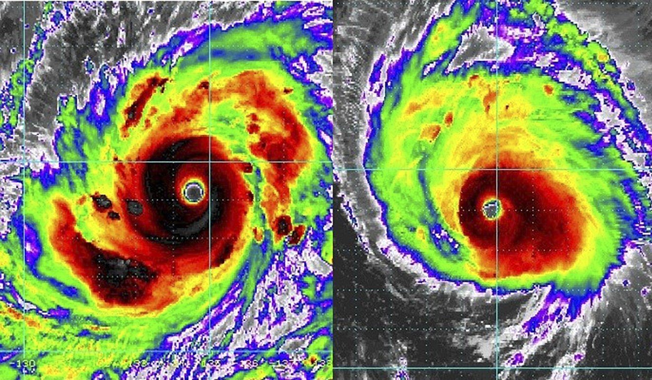
Super Typhoon Mangkhut predicted to be most powerful storm since records began and presents ‘great danger to Hong Kong’
Forecast from Observatory puts storm within 100km of city on Sunday, with sustained winds of up to 220km/h
Super Typhoon Mangkhut is predicted to be one of the strongest storms to ever hit the city and presents a “great danger to Hong Kong”, a top weather expert said on Tuesday.
The storm, which is forecast to be more powerful than any of the previous typhoons warranting Hong Kong’s highest warning signal, is predicted to pass within 100km of the city on Sunday.
And, Queenie Lam Ching-chi, senior scientific officer at the Hong Kong Observatory, said even if the super typhoon was further away, it could impact the city.
But, the forecaster’s tracking system shows a 70 per cent chance the tropical cyclone will deviate from its predicted path over the next four days.
According to the latest update at 8am on Wednesday, the super typhoon is expected to be closest to the city on Sunday, about 100km southwest of Tsim Sha Tsui, where the Observatory has its headquarters.
Lam Chiu-ying, a former director of the Observatory, said there was still a lot of uncertainty about Mangkhut’s path because it needed to first pass through the narrow Luzon Strait between Taiwan and the Philippines before hitting Hong Kong.
Typhoon signal No 3 issued as winds strengthen with Barijat’s approach
“Its intensity can be reduced if it hits land on either side [of the strait],” Lam said. “Since it’s still so far away from Hong Kong, its path can easily deviate several hundreds of kilometres from the predicted path.”
Lam, meanwhile, said it was still too early to say whether Mangkhut would directly hit the city.
“But it could be very close to Hong Kong,” she said. “It has a large circulation with intense winds, so even if it’s not a direct hit, there could still be an impact on Hong Kong.
“It can constitute a great danger to Hong Kong.”
Lam said the weather on Sunday would be “relatively adverse”, with low-lying areas facing risks of flooding and seawater intrusion. She advised citizens to take typhoon precautions beforehand.
She added that the Observatory would issue “appropriate warning signals based on the actual situation”.
A typhoon is often referred to as hitting Hong Kong directly if it passes within 100km of the city.
Forecasters predict that if it maintains its present course then at 8am on Sunday the typhoon will be about 240km southeast of the city, with winds reaching some 220km/h (137mph).
However, while the forecast path of Mangkhut indicates the most likely track the super typhoon will take, the actual path may deviate significantly, especially considering the typhoon is at least three days away.

The Observatory’s tracking system shows a 70 per cent probability that Mangkhut could deviate within a 500km radius from its predicted position closest to the city, leaving a lot of uncertainty over the next few days.
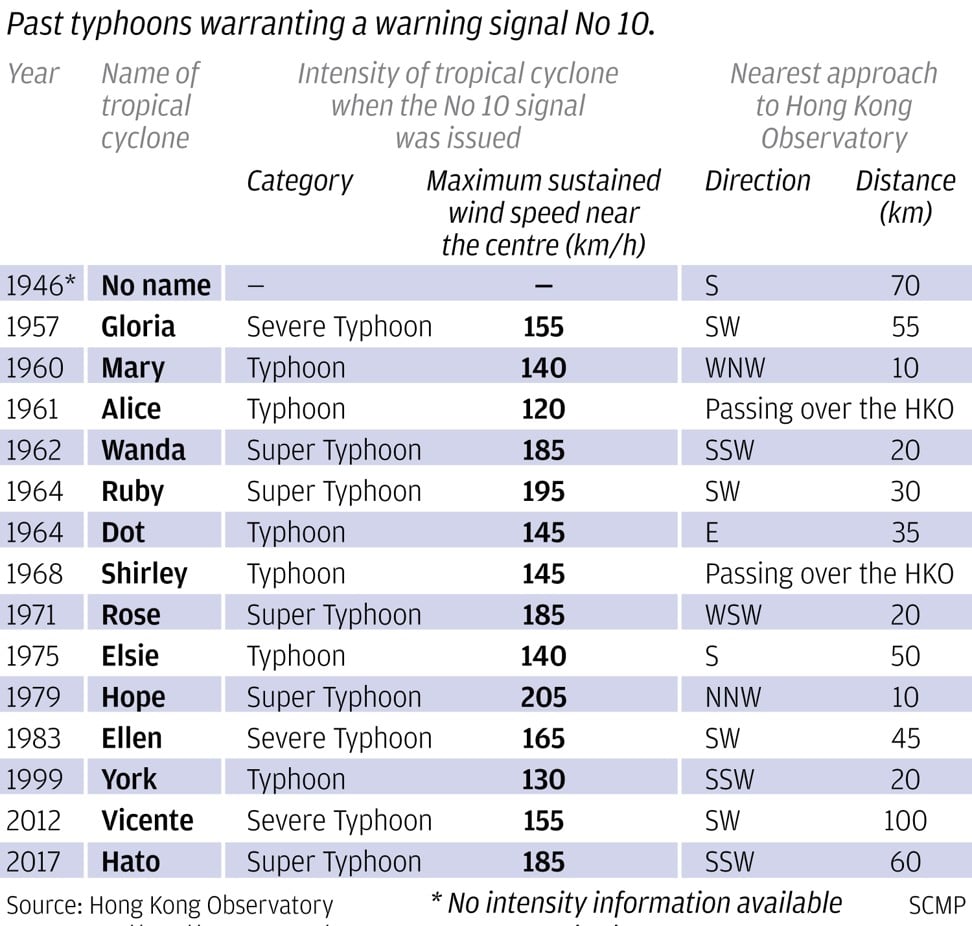
Even so, the forecast wind speed is predicted to be the strongest since records began in 1946, and stronger than any of the 15 past severe or super typhoons that warranted the highest No 10 warning signal.
Under the tropical cyclone classification system, typhoons have an intensity of between 118 and 149km/h, severe typhoons range between 150 and 184km/h, while super typhoons see a maximum wind speed near the centre of 185km/h or above.
Taiwan braces for impact as super typhoon Mangkhut approaches
A No 10 tropical cyclone warning signal indicates that a typhoon’s intensity is expected to reach at least 118km/h (73mph), and gusts may reach 220km/h.
Super Typhoon Hato in August last year, for example, prompted the Observatory to issue the No 10 signal. It reached 185km/h (115mph) at its peak intensity. Its closest distance to the Observatory’s headquarters was 60km (37 miles).
The recorded No 10 tropical cyclone with the highest intensity was Super Typhoon Hope in 1979, which reached 205km/h (127mph). It was 10km (6 miles) from the Observatory’s headquarters.
The notorious 1962 Super Typhoon Wanda, which killed 130 people and left 72,000 homeless, had an intensity of 185km/h and was 20km away from the headquarters.
On Tuesday, Britain updated its travel advice on Hong Kong, cautioning visitors to be aware of “hazardous sea and weather conditions” brought by Mangkhut.
Airlines based in the city – Cathay Pacific Airways and Cathay Dragon, Hong Kong Airlines and HK Express – announced they would waive rebooking fees for passengers scheduled to travel on Sunday and Monday, with some conditions attached.
Cathay Pacific and Cathay Dragon said only tickets issued worldwide on or before Tuesday, September 11, would be eligible for the rebooking and rerouting fee waiver.
Hong Kong Airlines had a similar arrangement for flights between September 16 and 18, while HK Express said it would waive fees for rescheduled trips on the same route, but would charge the fare difference if the route changed.
Typhoon season is here - all you need to know in Hong Kong
Mangkhut is expected to pass Taiwan on Saturday, with a 25 to 46 per cent chance it will directly hit the southern part of the island, according to the Taiwan Central Weather Bureau, which predicted an intensity of 198km/h (123mph) at 2pm on Saturday.
The super typhoon will then continue to move west towards Hong Kong, and is likely to be closer to the northern Philippines than to Taiwan on Saturday.
The storm swept by Guam on Monday, when its intensity was 145km/h. It caused flooding and power outages.
Mangkhut looks on its path to be one of the strongest tropical cyclones to hit Southeast Asia.
In 2013, Super Typhoon Haiyan, with a peak intensity of 285km/h (177mph), killed at least 6,000 people in the Philippines, injuring some 28,000.
Three years later, Super Typhoon Haima hit the northern Philippines with 250km/h (155mph) winds, killing at least eight and affecting more than 90,000 people.
Earlier this month, Super Typhoon Jebi landed in Japan at a speed of 174km/h (108mph), the strongest to hit the country in 25 years, killing at least 11 and injuring more than 600. It wreaked havoc in the country’s Kansai area, flooding the international airport in Osaka.


