
Confluence of events made Sandy such a big storm
Sheer size and unseasonal timing make Sandy a bizarre mix of hurricane, cold front and blizzard
Sandy seems like a storm created for a Hollywood apocalyptic blockbuster. But a confluence of environmental and topographical characteristics helps explain its vast size, slow progress, storm surge and multiple methods of wreaking havoc on the coast and deep inland, scientists say.

The tropical-storm winds that constitute Sandy at one stage stretched 1,500 kilometres, said Jeff Masters, co-founder of the website WeatherUnderground. com and a former flight meteorologist "hurricane hunter" with the National Oceanic and Atmospheric Administration (NOAA). Sandy is the largest such storm to make landfall on the Atlantic seaboard since the federal government began keeping records in 1988, he said.
Sandy's course, from the southeast to the northwest, is not typical, according to Rick Knabb, director of NOAA's National Hurricane Centre in Miami. Although its path is "not 100 per cent unprecedented", it is unusual to have a storm of such size and strength coming inland so late in the year, Knabb said on Monday.
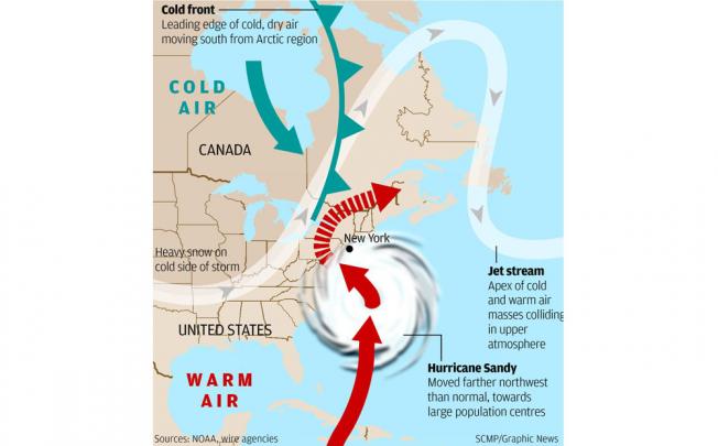
Even when Atlantic storms come inland, they usually head out to sea. Some very powerful storms in recent years did not make landfall at all, kept away by onshore weather patterns. But Sandy was pushed ashore into the mid-Atlantic states and New England because a high-pressure system near Greenland blocked its progress eastward.
That shift towards the northwest put Sandy on course to mesh with a cold front that began in California last week and has marched across the country, creating what Knabb and others call an unprecedented weather threat. The force of the eastward-moving front has slowed Sandy, Garrett said, and is changing the hurricane into a "Nor'easter", or cold front.
Sandy had started losing traits typical of tropical storms, such as thunderstorms at its middle, Garrett said. Instead, Sandy's merger with the cold front threatens severe snow in places. More than a metre of snow was predicted in West Virginia, with lesser falls in southwestern Virginia and western North Carolina.
"It's not just a tropical storm, but a wind storm, a snow storm," Garrett said.
Sandy's record-setting storm surges were a result of the swirling movement of its wind creating a bulge of water that typically move to a storm's centre. There, the low pressure in the atmosphere acts like a straw and pulls the water levels even higher, Masters said.
If Sandy were out to sea, that bulge would eventually sink. But as Sandy passed over the coast, that bulge had nowhere to go but towards shore, he said.
